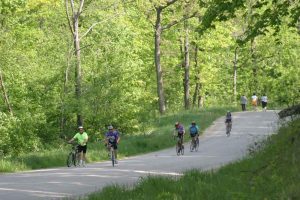
Biking
The Driftless Wisconsin area in the southwest region of the state provides many choices for bike riders, from rugged mountain trails to challenging on-road routes to constructed bike trails.
Biking
The Driftless Wisconsin area in the southwest region of the state provides many choices for bike riders, from rugged mountain trails to challenging on-road routes to constructed bike trails.
Crawford County has charted nine tours using “roads as routes,” a combination of country and township roads that allow bicyclists to enjoy the scenic rural landscape. The tours are: the 42-mile Wauzeka Corridor; 35-mile De Soto Loop; 44-mile Ferryville Loop; 33-mile Seneca Loop; 39-mile Eastman Loop; 22-mile Prairie du Chien Loop; 28-mile Mt. Zion Loop; 18-mile Gays Mills Loop: and 14-mile Soldiers Grove Loop. Vernon Trails has mapped six off-road trails: Sidie Hollow, Jersey Valley, Hubbard Hills, Rusty Ridge, Davidson Park, and Winter Fat Bike Trails.
 If off-road biking is your preference, the Kickapoo Valley Reserve boasts 24 miles of trails and Wyalusing State Park has 4.9 miles of trails. Enthusiasts have been hard at work creating six miles of new mountain bike trails at Sidie Hollow County Park near Viroqua, and plan more for Duck Egg Forest and Hubbard Hills,
Wilton, the northernmost point of the Kickapoo Valley, is the mid-point of the 32-mile Elroy-Sparta State Trail. This three-tunnel trail has been inducted into the Rail-Trail Hall of Fame and is a favorite for family outings.
Driftless Area Wisconsin Biking Routes
Wauzeka Corridor
42 miles; 86% paved*; parking at boat landing
The Kickapoo River will be your companion for much of the way on this unforgettable ride along the back roads that parallel the river. Before you saddle up in Wauzeka, a quiet community located at the confluence of the Kickapoo and Wisconsin Rivers, you’ll want to visit Kickapoo Indian Caverns, a natural treasure carved by underground rivers. Beginning in Wauzeka, your journey upriver into the throat of the Kickapoo Valley will take you through some of the most scenic stretches in the Midwest. Entering this magical valley, you will soon lose your troubles along winding roads that bend to the whims of the river, which judging by its convoluted path, seems at times to lose its way. No matter, for your own path follows the lay of the land, from secluded natural prairies with blooming wild flowers, sedate farmsteads with grazing cattle, then back to lazy stretches of river. The route is long, but not overly challenging; the roads tend to stay near the river, with sections that climb briefly from the valley, but quickly return. Smaller communities greet you along the way, with plenty of opportunities to stop and contemplate the “crookedest river in the world.”
De Soto Loop
35 miles; 60% paved*; parking at ball field
The De Soto loop is not for the faint of heart, with a challenging climb at the end rewarded by a heart-stopping overlook of the Mississippi River. We recommend that you take this route in a counterclockwise direction, as Lawrence Hill Road above De Soto is best enjoyed descending in a cool breeze rather than ascending in a warm sweat. Your ride south along Highway 35 takes you along a scenic stretch of the Mississippi River, then left into Rush Creek Natural Area – about 4 miles south of De Soto – which features a pristine goat prairie on the slopes above the limestone cliffs, accessible by walking trail. County B out to Rising Sun is a bit of a rollercoaster, but levels out eventually into a spectacular view. Then it’s back onto Rush Creek Road, a gravel road that runs along the creek bed, framed on either side by gurgling water and limestone outcroppings. Coulee Creek Road takes you on a more gradual, but lengthy climb to the bluff overlooking De Soto, where a sliver of the Mississippi can be seen glistening down in the river valley. Besides the dramatic overlook and picturesque bluffs, De Soto also offers a bit of history at Black Hawk Recreation Area. Located right on the banks of the Mighty Mississippi, the park features riverside camping and a historical marker commemorating the spot where Chief Black Hawk and his band of Sauk followers made their historic stand against the U.S. infantry.
Ferryville Loop
44 miles; 93 % paved*; parking at Sugar Creek Park south of town
In Ferryville, overlooking one of the widest stretches of river on the Upper Mississippi, you’ll find plenty of hospitality and opportunities to satisfy your appetite for food and drink. On Saturdays, Sugar Creek Park comes to life with the Market in the Park, featuring crafts make by regional artists. Your tour begins on Buck Creek Road, a gradual ride upward through the ravine with Buck Creek meandering downward on your right. At the crest of the hill, Boma Road rambles through rolling farmlands accented with barns and ball-top silos. Crossing Highway 27 at Fairview, a fair description of the scenery visible from this lofty town, Johnstown Road takes you on a rollercoaster ride into Johnstown Valley. Stop at the Blackhawk-Kickapoo Watershed Project, a floodwater retention dam that dominates the valley topography. Turning right on County B, the landscape broadens into the stunning Kickapoo Valley. Then left on River Road, where the road weaves and winds with the river, offering several overlooks for photographs. Norwegian Hollow Road offers an easy frolic through the valley bottom before ascending to the top – northern border, that is – of Crawford County. Latham Road is one of the most secluded stretches of this tour, winding through a relatively unpopulated and unvisited portion of the county. County B straddles the peak between Crawford and Vernon Counties, presenting a spectacular view of the Driftless Region of Southwest Wisconsin.
Seneca Loop
33.1 miles; 100 % paved*; parking on street or at town hall
Your route begins in Seneca, featuring Johnson’s One Stop, a rural variety store that lives up to its name; Greener’s Corner, where you can get a quick snack; and a view of the surrounding river valleys that will never tire. Riding west along Short Cut, Oak Grove Ridge, and Kettle Hollow roads, you will drop gradually into the confines of the Mississippi River Valley. Kettle Hollow Road is gravel, but you’ll be rewarded with an enjoyable ride through a canopied coulee. A left onto Highway 35 will take you along the wide expanse of the Mississippi, where you may want to stop at the Historic Marker (one mile off-route, south of Lynxville) commemorating rafting on the Mississippi. Then it’s back up to the ridge along Bernhardt Ridge Road, notched into the hillside with the valley unfolding to your right. After crossing Highway 27, Burns Road takes you on catwalk through the cornfields atop the ridge, before plunging headfirst into the grassy bottoms of Pine Creek Valley along Duha Ridge Road. You’ll briefly encounter moderate traffic along State Highway 171 and County E, before escaping into one of the most enjoyable segments of the route; Citron Valley Road, which zigzags across the secluded valley and around the “Hogback,” a unique geologic formation maintained by The Nature Conservancy. Next, it’s up to Taylor Ridge Road, a wooded ridgeline that opens into an expansive panorama of farmland dotted with farmhouses and barns, before returning to Seneca.
Eastman Loop
39 miles; 92% paved*; parking on street
Eastman, the quintessential farming community, welcomes you to its unsurpassed ridge-top scenery, and to a route that takes you into the heart of the landscape that makes Crawford County so special. Traveling east along the ridge extending from Eastman, you will view the spectacular breadth of the Kickapoo Valley before dropping into its midst. The route parallels the boundary of the Kickapoo Valley State Wildlife Area, where you’ll see first-hand the intertwining ravines and native prairies that make the Kickapoo Valley a refuge of tranquility. After joining the Kickapoo River Corridor route that takes you through Wauzeka, you will once again ascend to the ridge, this time to stop and appreciate the expansive Wisconsin River Valley that opens to the south. Then it’s over the ridge along Limery Road into the Mississippi River Valley – the third and most spectacular river valley on your tour. Be sure to stop at Shihata’s Orchard for some home-grown apples or delicious preserves. Your final leg will take you along the river bottoms and backwaters of the Mighty Mississippi, before glimpsing the old river herself and climbing back to Eastman.
Prairie du Chien Loop
22.3 miles; 93% paved*; parking at St. Feriole Island Ball Field
The route begins on historic St. Feriole Island in Prairie du Chien, next to Lawler Park on the Mississippi riverfront, and near the Villa Louis Historic Site, billed as “one of the most authentically restored Victorian house museums in America.” Travel north along the tranquil backwaters of the Mississippi, then east through picturesque Limery coulee before climbing the ridge overlooking the river valley. The ride eastward along the ridge top meanders through the high country checkered with dairy farms as deep ravines cascade toward the river on either side. Be sure to stop at the intersection of Bouska and South Ridge roads for a spectacular view of the Wisconsin River Valley, before descending back to Prairie du Chien. Along your return route, you will find the Ft. Crawford Museum, site of the reconstructed Fort Crawford Hospital where Dr. William Beaumont performed his famous experiments on the human digestive system. As Wisconsin’s second-oldest community, Prairie du Chien possesses a wealth of historic and natural attractions, as well as a variety of dining and lodging selections to complete your day along the Mighty Mississippi.
Mt. Zion Loop
28.4 miles; 98% paved*; parking at Mt. Zion Bar
It seems that Mt. Zion is a preferred destination for riding bicycles – and riding lawn mowers. This small town of 35 people was the last stop for Alvin Straight, and a filming location for the 1999 movie, “The Straight Story,” about a 73 year-old man who rode 300 miles on a lawn mower to see his ailing brother. Whether by mower or bicycle, this 28 mile loop will charm you with its exceptional scenery and challenging terrain. After traveling north on Highway 61, County S descends from ridge top to valley bottom, before Remington Hill rises steeply back to the peak. You’ll encounter about one-half mile of gravel on West Ridge Road, but on level ground. North Irish Ridge has nice views and is fairly level until it drops down a steep hill – about one-half mile – back to Highway 61. Spring Valley Road passes by St. Isaacs Skete, site of an Eastern Orthodox Christian Monastery with a bookstore and gift shop. Spring Valley and Haney Ridge offer a gradual, rolling climb; a pleasant ride that passes several old cemeteries worthy of investigation. Juddy Smith Road drops down quickly to Highway 131 and Petersburg (no facilities). County S and Highway 61 return to Mt. Zion, where you may want to catch a beer after a long, rewarding ride – just as Alvin did after 300 miles on a lawn mower.
Gays Mills Loop
18 miles; 84 % paved*; parking at Museum of the Kickapoo near the river
Gays Mills, with a population of around 600 people nestled along the Kickapoo River, boasts some of the best apple orchards in the Midwest. Site of the Crawford County fairgrounds, Gays Mills also has restaurants and retail shops to enjoy during your stopover. West River Road takes you along the pastured river bottoms of the Kickapoo, then left on Sand Hill Road before sending you upward along Bell Center Road to the wood-lined top of the ridge, which opens up to a wide panorama of the valley and creek bed below. The rolling ridge of Bell Center Road leads eventually to the tree tunnel, a phenomena surely to invite a stop and a photograph. Then it’s on to Rolling Ground, with the topography to match, and Murphy’s Tavern, a good spot to stop for a drink or a bite to eat. Nearby are Hillcrest Apple Orchard, an old cemetery, and a nice wayside with bathrooms. Sand Creek Road, a narrow and heavily wooded road that gradually opens to old farms and rock outcroppings jutting out along the creek, takes you down to West River Road and back to Gays Mills.
Soldiers Grove Loop
14.5 miles; 100% paved*; parking at Beauford T. Anderson Memorial Park
Your journey begins in Soldiers Grove, site of Solar Town (America’s first solar village), the Veteran’s Memorial and Region 5 Medal of Honor Wall, and opportunities for dining and lodging. Beauford T. Anderson Park, site of the 2007 Driftless Area Art Festival, offers riverside camping along the banks the Kickapoo, as well as shelters for picnics and group outings. Ride north on Highway 61 to Trout Creek Road, where this quiet valley road will treat you to interesting rock outcroppings, reclusive farm settings, and the easy wanderings of Trout Creek herself. McDaniel Road takes you upward on a long winding climb through quiet Amish farms and hillside pastures. A rolling ridge top ride will greet you at the top, affording a memorable view of the Driftless landscape, before descending once again into the valley. Dull Road offers a steep descent – about a mile long – rewarding you with a long glide back down North Clayton Road to Highway 61, and back to Soldiers Grove.
Amish Tour
29.7 miles/48k
At the Stabbur in Westby, take Black River Avenue north to County Road P. Go right on County P for 4.3 miles. At Knapp Valley Road, take a left and proceed to the T intersection. At County D, turn right. (County D will switch to County P on the route). Continue to the intersection of County Roads P and S. Take County S left through the village of Bloomingdale and then into the village of Avalanche. At the intersection of County Y, take a right and go 2.3 miles to a right turn on Smith Road. At the top of the hill, take a right on Coon Prairie Road, which will lead you back to the Stabbur.
Ski Jump Tour
21.6 miles/37k
At the Stabbur in Westby, take Black River Avenue north to County Road P, then take a left and cross Highway 27. Where the road becomes Saugstad Road, go 1/4 mile to Kolbo Avenue and turn right. This road takes you into the valley of Timber Coulee. Turn left on County P and follow this road for 12.1 miles. You will pass the Snowflake Ski Jumping Complex and Golf Course and Skogdalen Lutheran Church while riding the Timber Coulee’s trout stream bed. At Spring Coulee Road (not Spring Coulee Ridge Road) you begin the trip back to Westby. At 15.5 miles there is a great rest area by a bridge before the road takes off in a steady climb for 1.5 miles. At the top you will turn Hegge Road. Cross over Highway 14/61 and continue on Hegge Road to a four-way stop at the 20-mile mark. Turn left on Unseth Road. Unseth Road will turn into West State Street at the city limits. Follow West State Street across Main Street to East State Street, and take first left on Bekkedal Avenue to get back to the Stabbur.
Kickapoo Valley Tour
40.5 Miles/65K
At the Stabbur in Westby, take Black River Avenue north to County Road P. Go right on County P and continue for 11 miles. Take a left on 24 Valley Road, then take the second right on Fish Valley Road. At the T intersection (Sand Hill Road), take a right and proceed for a little ways until you come to a Y intersection. Take a left onto Dutch Hollow Road and continue for 3 miles. At the next T intersection, Highway 131, take a right and head toward the village of Rockton. Stay on Hwy 131 by crossing over the bridge and going to La Farge. (Take time out of the trip to stop at the Kickapoo Valley Reserve’s Visitor Center on the right.) Turn right on Highway 82 and continue for 7.8 miles to County S. Take a right on County S, and the road will lead you to the village of Avalanche. Cross over the bridge and take County Y for 2.3 miles to a right turn on Smith Road. At the top of the hill, take another right on Coon Prairie Road, which will lead you right back to the Stabbur
West Fork Tour
Short Cut Return At the intersection of County S and County Y, take a right on County Y and follow the road for 2 miles. Turn right on Smith Road, with an incline to Coon Prairie Road which will lead you right back to the Stabbur.
Long Route
Turn left (south) on County S, and cross over Highway 82 to the town of Liberty. At the intersection of Highway 56, turn right. Go right 1 mile on an uphill grade, then turn right on County SS. Turn right on Highway 14, which will lead you to the city of Viroqua. Turn right on Decker Street, left on North East Avenue, then right on Linton Street, and left on Railroad Avenue. Continue on County Y by bearing left at all the yield signs and stop signs. Once on County Y, turn right and follow the road for 4.1 miles to a left turn on Smith Road . Turn right on Country Coon Prairie Road which will lead you right back to the Stabbur.
Small Town Charm
42.5 Miles/68K
At the Stabbur in Westby, go right/south on Bekkedahl Avenue, then take another right on Coon Prairie Avenue. Continue to Main Street, then take a left on Main Street. Just past Accelerated Genetics, take a right on Old Town Road. At the first four-way intersection, take a left on Barstad Road, and follow this road to the third intersection. At Three Chimney Road, take a right at the stop sign, then continue on Three Chimney by taking a left at the Yield sign. Follow this road for 1/2 mile to County Y, and take a right. You will soon reach County B, where you take a right and proceed to the village of Esofea. (Take Park Road if you need a restroom break or to have a picnic.) At the Intersection of County B and KK, take a left on KK up a gradual hill. Follow KK for 4.1 miles until you reach Enterprise Road, where you will take a left. Follow Enterprise for 1.1 miles to a T intersection, and take a right on County O (which will turn in to CTY KO); follow for 5.9 miles. At the next T Intersection, turn right on County O to the first right turn on Hunder Coulee. You will take this down the hill to Highway 162. Take 162 to the right into lower Chaseburg. Continue on the 162 loop through town, leading up to upper Chaseburg. Continue for 5 miles. At Highway 14, take a right and proceed to Coon Valley. At the end of town you will take a left on County P. At Spring Coulee Road, take a right and continue for 6.6 miles. At the top of the ridge, take a right on Hegge Road which will cross Highway 14. At the four-way intersection, take a left on Unseth Road, which lead to Westby. When In Westby, cross over the highway to East State Street, then the next left on Bekkedahl Avenue which will lead you to the Stabbur.
Warnings About Driftless Area Wisconsin Biking
Beware of increased traffic on state and county highways. Some paved roads are seal-coated, which may contain loose gravel.


Request our Brochure!
Whether for a weekend, a week, or longer, you’ll enjoy your stay in Driftless Wisconsin. Love using our map while exploring the Driftless? Leave us a Google 5-star review!